Friday, December 09, 2005

http://local.live.com/


Well, another mapping service popped up. Microsoft inproved its msn virtual earth to create http://local.live.com. Some gui-improvements are implemented, but the most interesting thing are the bird-eye views of some mayor downtown areas in the US. Pictures have been taken by Pictometry International Corp. with low flying airplanes. From each point you can look into four directions.

Friday, December 02, 2005

MapServer + Autodesk = ... Enterprize?


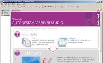
This week autodesk and mapserver announced a cooperation in a new project MapServer Enterprize. A GPL project in which both organisations combine their technologies, to generate a new open source gis internet tool in which developers can use php, .net or java. New for the mapserver users are autodesks vector-viewing possibilities (where is SVG/GML?) and a desktop tool to configure the gis-data (at last!).

Well good news i guess. Though autodesc, not specifically being a GIS company, might not be my first choise to cooperate with. However they have a zilion of users. If they all are using MapServer soon, the comunity will be bigger than the mozilla team...

Download an early release here: http://www.mapserverfoundation.org/mapserver_enterprise

Monday, November 28, 2005

wkt syntax (howto)

Geometry types and their text representations


Geometry typeWKT representationComment
pointPOINT EMPTYempty point
pointPOINT ( 10.05 10.28 )point
pointPOINT Z( 10.05 10.28 2.51 )point with Z coordinate
pointPOINT M( 10.05 10.28 4.72 )point with M coordinate
pointPOINT ZM( 10.05 10.28 2.51 4.72 )point with Z coordinate and M coordinate
linestringLINESTRING EMPTYempty linestring
polygonPOLYGON (( 10 10, 10 20,20 20, 20 15, 10 10))polygon
multipointMULTIPOINT Z(10 10 2, 20 20 3)multipoint with Z coordinates
multilinestringMULTILINESTRING M(( 310 30 1, 40 30 20, 50 20 10 )( 10 10 0, 20 20 1))multilinestring with M coordinates
multipolygonMULTIPOLYGON ZM((( 1 1 1 1, 1 2 3 4, 2 2 5 6, 2 1 7 8, 1 1 1 1 )))multipolygon with Z coordinates and M coordinates

Thursday, November 24, 2005

Advanced drawing in chameleon

Today i noticed the guys at http://www.uwaterloo.ca have been working on some really advanced javascript drawing techniques for chameleon. They used walter zorn's drawing library to create dynamic circle and polyline drawing tools.

Wednesday, November 23, 2005

opensource gis desktop clients

Recently some opensource (free) desktop GIS clients came to my attention.

Basic clients

openEv is a basic gis-viewer by frank warmerdam (http://fwtools.maptools.org/ )

development environments

Lots of groups offer platfoms in which you can easily build your own desktop gis client.

http://www.geovistastudio.psu.edu

http://www.vividsolutions.com/jts/jtshome.htm

http://openmap.bbn.com

Free clients
- the guys at http://www.tatukgis.com created a Delphi.net environment in wich you can build your own viewer with a few clicks. But they also offer e simple viewer for free. Tatuk manages to put all gis-functionality in just a tiny 10mb application.

soon to come
- At http://fmaps.sourceforge.net they are coding to bring a decent gis-client to the linux-platform. They use postgis to store data.